Please create a highly finished, high-quality "Landscape Archive Model" visual suitable for serialized publishing based on 【{argument name="Theme" default="Theme"}】.
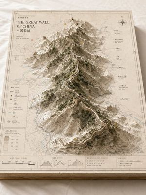
This is not an ordinary map, nor is it a standard landscape illustration or city rendering. It is a high-end archival visual that combines "2D map drawings + 3D regional models + professional annotation systems + museum exhibition aesthetics". The image should look like a real, physically crafted geographical research model, urban planning sandbox, architectural proposal model, or world-building exhibit, possessing a professional, restrained, precise, and tactile premium quality.
【Basic Settings】
Theme: 【{argument name="Theme Content" default="Theme, e.g., Crater Lake / Guangzhou / Chongqing Mountain City / Island City / Ancient Ruins / Doomsday Wasteland / Fantasy Continent / Game Main City"}】
Theme Type: 【Natural Landform / Urban Space / Mixed Landscape】
Core Subject: 【{argument name="Core Subject" default="Core Subject, e.g., crater, canyon, mountain range, lake, CBD, old town, landmark group, island city, ruins, main city area"}】
Content Focus: 【Content Focus, e.g., terrain elevation / city landmarks / road network structure / water system relations / nature-city relationship / setting exhibition】
Style Direction: 【Style Direction, e.g., geographic mapping style, paper carving model style, architectural proposal style, museum archive style, urban planning style, game artbook style】
Main Color Tone: 【Main Color Tone, e.g., off-white, light gray, parchment white, sand color, snow white】
Secondary Color: 【Secondary Color, e.g., earth brown, rock gray, cool gray, light blue, moss green】
Accent Color: 【Accent Color, e.g., fine black lines, red routes, blue hydrological lines, yellow numbering marks】
Aspect Ratio: 【Aspect Ratio, e.g., 16:9 landscape / 3:4 portrait / 4:5 portrait / 1:1 square】
【Visual Structure】
The main subject is a rectangular map model board placed on a clean desk or white cloth. The baseboard has real thickness, with visible cross-sectional structures at the edges, like a delicate map slice or model base. The map surface is covered with a clear but restrained information layer, including contour lines, road networks, hydrological lines, zoning boundaries, geographical textures, coordinate grids, subtle annotations, and drawing borders.
In the center or slightly off-center of the map, a 3D main model "grows" out of the 2D map, becoming the visual core of the entire image.
If 【Theme Type】 is Natural Landform:
The main body can consist of mountains, canyons, craters, lakes, basins, islands, glaciers, faults, coastlines, etc., emphasizing terrain elevation, layered contour structures, rock textures, and natural undulations.
If 【Theme Type】 is Urban Space:
The main body can consist of core urban areas, CBDs, old town blocks, landmark buildings, waterfronts, road network nodes, bridges, water systems, parks, etc., emphasizing building volumes, urban recognizability, spatial hierarchy, and planning structure.
If 【Theme Type】 is Mixed Landscape:
It must integrate both natural terrain and artificial built environments, such as mountain cities, island cities, ancient ruins, doomsday wastelands, fantasy main cities, sci-fi bases, etc., allowing natural landforms and urban structures to jointly form the core visual.
【Detail Requirements】
- The model surface retains the feel of map drawings and professional information.
- Terrain areas should have contour lines, slope layers, and depression/elevation relationships.
- Building areas should have a sense of volume, block relationships, and clear hierarchy.
- Water bodies are represented in low-saturation light blue.
- Green spaces, forests, parks, and mountains can be represented in moss green or low-saturation green.
- Road networks, paths, traffic axes, or exploration routes can be represented by fine lines, but should not overpower the main subject.
- If there are landmark buildings or key structures, they should be clearly recognizable.
- If there are fantasy, sci-fi, or game setting elements, they should retain the feel of an archival model and drawing exhibition, rather than a pure scene illustration.
【Annotation System】
The edges of the map board need a complete and restrained annotation module, including:
- Outer and inner border lines
- Scale bar
- Legend area
- Title area
- Archive number
- Index marks
- Annotation labels
- Concise symbol explanations
The text does not need to be entirely legible, but the overall layout must present a real, clear, precise, and orderly archival typographic structure.
【Composition and Camera】
Use an oblique top-down isometric or sandbox-style composition. The camera observes the entire model board from above at an angle of about 30 to 45 degrees, allowing the audience to simultaneously see the map plane, the height of the 3D subject, the edge thickness, and the annotation area. The visual focus is on the central main model. The reading path is: first the core subject, then the surrounding terrain/road network/water system/block information, and finally the legend, scale, and annotation area.
【Materials and Lighting】
The overall image needs to have the texture of real model photography:
- Paper texture
- Map printing texture
- Paper carving or sandbox model feel
- Architectural model or terrain slice texture
- Soft natural light
- Delicate and realistic shadows
- Clean background
- Low saturation, premium, restrained
Avoid cartoonish looks, cheap game UI feels, excessive clutter, or over-the-top effects. Focus on highlighting the unified visual of "map baseboard + 3D subject + professional annotation system".
The final result should look like a landscape archive model image that can be used for geographical popularization, urban research, architectural proposals, cultural tourism visual features, world-building artbooks, or high-end series covers.